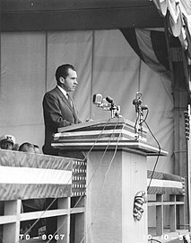
 Vice-President Richard Nixon speaking at The Dalles Dam dedication in 1959.
 The Dalles Dam site plan.
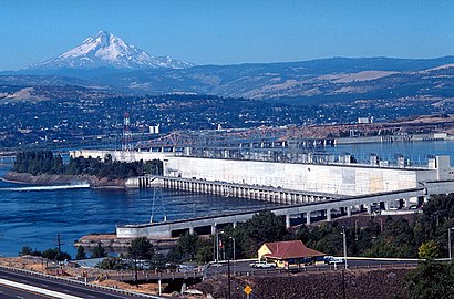 Looking west, fish ladder in the foreground, power generation center. Mount Hood rises in the background.
 The Dalles Dam in
June 1973.
energy.wikisort.org - Power_plant
The Dalles Dam is a concrete-gravity run-of-the-river dam spanning the Columbia River, two miles (3 km) east of the city of The Dalles, Oregon, United States.[2] It joins Wasco County, Oregon with Klickitat County, Washington, 300 miles (309 km) upriver from the mouth of the Columbia near Astoria, Oregon. The closest towns on the Washington side are Dallesport and Wishram.
| The Dalles Dam | |
|---|---|
 From the Washington side | |
| Official name | The Dalles Lock and Dam |
| Location | Klickitat County, Washington / Wasco County, Oregon, USA |
| Coordinates | 45°36′44″N 121°08′04″W |
| Construction began | 1952 |
| Opening date | 1957 |
| Operator(s) | U.S. Army Corps of Engineers (Operator) Bonneville Power Administration (Marketer) |
| Dam and spillways | |
| Type of dam | Concrete gravity, run-of-the-river |
| Height | 200 feet (61 m) |
| Length | 8,835 feet (2,693 m) |
| Width (base) | 239 feet (73 m) (Spillway) |
| Spillway type | Service, gate-controlled |
| Spillway capacity | 2,290,000 cu ft/s (65,000 m3/s) |
| Reservoir | |
| Creates | Lake Celilo |
| Total capacity | 330,000 acre⋅ft (0.41 km3) |
| Power Station | |
| Turbines | 22 |
| Installed capacity | 1,878.3 MW Max.: 2,160 MW |
| Annual generation | 6,180 GWh[1] |
The Army Corps of Engineers began work on the dam in 1952 and completed it five years later. Slack water created by the dam submerged Celilo Falls, the economic and cultural hub of Native Americans in the region and the oldest continuously inhabited settlement in North America.[3] On March 10, 1957, hundreds of observers looked on as the rising waters rapidly silenced the falls, submerged fishing platforms, and consumed the village of Celilo. Ancient petroglyphs were also in the area being submerged. Approximately 40 petroglyph panels were removed with jackhammers before inundation and were placed in storage before being installed in Columbia Hills State Park in the 2000s.[4]
The reservoir behind the dam is named Lake Celilo and runs 24 miles (39 km) up the river channel, to the foot of John Day Dam. The dam is operated by the U.S. Army Corps of Engineers (USACE), and the power is marketed by the Bonneville Power Administration (BPA). It is part of an extensive system of dams on the Columbia and Snake Rivers.
The Dalles Dam Visitor Center, in Seufert Park on the Oregon shore, was built in 1981. A tour train was closed in autumn 2001, partly due to post-September 11 security concerns, and partly due to deteriorating track conditions and a small derailment. The Columbia Hills State Park is nearby.
The Dalles Lock and Dam has been designated as a National Historic Civil Engineering Landmark by the American Society of Civil Engineers.[5]
Specifications

- Altitude: 79 feet (24 m) above sea level[citation needed]
- Height: 200 feet (61 m)[6] (Lake Celilo normal pool elevation 158 feet (48 m))[7]
- Length: 8,835 feet (2,693 m)[6]
- Navigation lock:
- Powerhouse:
- Spillway:
Gallery


See also
- List of dams in the Columbia River watershed
- List of largest hydroelectric power stations in the United States
References
- "Carbon Monitoring for Action | Center For Global Development".
- "The Columbia River System Inside Story" (PDF). BPA.gov. pp. 14–15. Retrieved 17 July 2010.
- Dietrich, William (1995). Northwest Passage: The Great Columbia River. Seattle, WA: University of Washington Press. p. 52.
- Banyasz, Malin Grunberg (May–Jun 2017). "Off the Grid". Archaeology. 70 (3): 10. ISSN 0003-8113. Retrieved 3 July 2017 – via EBSCO's Master File Complete (subscription required)
{{cite journal}}: External link in|postscript= - Goodell, Christopher R. (Spring 2014). "The Dalles Dam – An ASCE National Historic Civil Engineering Landmark" (PDF). EWRI Currents. 17 (2): 6–9. Retrieved November 24, 2021.
- "The Dalles Lock and Dam". National Performance of Dams Program. Archived from the original on 7 March 2016. Retrieved 1 March 2016.
- "The Dalles Lock and Dam Fact Sheet". United States Army Corps of Engineers. 2013. Retrieved 25 September 2020.
External links
Wikimedia Commons has media related to The Dalles Dam.
- The Dalles Lock & Dam - The U.S. Army Corps of Engineers
- "The Dalles Dam to Submerge Famous Indian Fishing Spot." Popular Mechanics, April 1956, pp. 138–140.
Crossings of the Columbia River | ||||
|---|---|---|---|---|
| ||||
| Authority control: National libraries |
|---|
На других языках
[de] The-Dalles-Talsperre
Die The-Dalles-Talsperre (englisch The Dalles Dam) ist eine Staustufe am Columbia River, drei Kilometer östlich der Stadt The Dalles in Oregon, USA. Die Talsperre hat eine L-förmige Beton-Gewichtsstaumauer mit einem Laufwasserkraftwerk und staut seit 1957 den Columbia zum Lake Celilo auf, der sich 39 km flussaufwärts nach Westen bis zur John-Day-Talsperre erstreckt. Die The-Dalles-Talsperre wird vom United States Army Corps of Engineers betrieben und verbindet wie die flussabwärts folgende The Dalles Bridge das Wasco County in Oregon mit dem Klickitat County in Washington. Sie liegt 309 km flussaufwärts von der Mündung des Columbia bei Astoria und grenzt an den Lake Bonneville der nächsten Staustufe, die Bonneville-Talsperre.- [en] The Dalles Dam
[fr] Barrage de The Dalles
Le barrage de The Dalles (anglais : The Dalles Dam) est un barrage sur le fleuve Columbia près de The Dalles à la frontière entre les États de Washington (comté de Klickitat) et de l'Oregon (comté de Wasco), aux États-Unis.[ru] Дамба Даллеса
Дамба Даллеса (англ. The Dalles Dam) — русловая ГЭС на реке Колумбия в 3 километрах к востоку от городка Даллес, штат Орегон, США[1]. Дамба расположена на границе округов Васко в Орегоне и Кликитат в штате Вашингтон в 309 километрах вверх по течению от устья Колумбии около города Астория в Орегоне. Ближайшие к дамбе города на стороне штата Вашингтон: Даллеспорт и Уишрам.Текст в блоке "Читать" взят с сайта "Википедия" и доступен по лицензии Creative Commons Attribution-ShareAlike; в отдельных случаях могут действовать дополнительные условия.
Другой контент может иметь иную лицензию. Перед использованием материалов сайта WikiSort.org внимательно изучите правила лицензирования конкретных элементов наполнения сайта.
Другой контент может иметь иную лицензию. Перед использованием материалов сайта WikiSort.org внимательно изучите правила лицензирования конкретных элементов наполнения сайта.
2019-2026
WikiSort.org - проект по пересортировке и дополнению контента Википедии
WikiSort.org - проект по пересортировке и дополнению контента Википедии