energy.wikisort.org - Power_plant
Dartmouth Dam is a large rock-fill embankment dam with an uncontrolled chute spillway across the Mitta Mitta, Gibbo, and Dart rivers, the Morass Creek and a number of small tributaries. The dam is located near Mount Bogong in the north-east of the Australian state of Victoria. The dam's purpose includes irrigation, the generation of hydro-electric power, water supply and conservation. The impounded reservoir is called Dartmouth Reservoir, sometimes called Lake Dartmouth. The Dartmouth Power Station, a hydro-electric power station that generates power to the national grid, is located near the dam wall.
| Dartmouth Dam | |
|---|---|
 Dartmouth Dam wall, pictured in April 2003 | |
 Location of the Dartmouth Dam in Victoria | |
| Country | Australia |
| Location | Victoria |
| Coordinates | 36°33′29″S 147°31′25″E |
| Status | Operational |
| Construction began | 1973 |
| Opening date | 1979 |
| Construction cost | A$139 million |
| Owner(s) | Murray Darling Basin Authority |
| Operator(s) | Goulburn–Murray Water |
| Dam and spillways | |
| Type of dam | Embankment dam |
| Impounds |
|
| Height | 486 m (1,594 ft) AHD |
| Height (thalweg) | 180 m (591 ft) |
| Length | 92 m (302 ft) |
| Width (crest) | 670 m (2,198 ft) |
| Width (base) | 700 m (2,297 ft) |
| Dam volume | 14.1×10⁶ m3 (498×106 cu ft) |
| Spillway type | Uncontrolled chute |
| Spillway capacity | 2,750 m3/s (97,115 cu ft/s) |
| Reservoir | |
| Creates | Dartmouth Reservoir |
| Total capacity | 3,856 GL (848×109 imp gal; 1,019×109 US gal) |
| Inactive capacity | 71 GL (16×109 imp gal; 19×109 US gal) |
| Catchment area | 3,600 km2 (1,390 sq mi) |
| Surface area | 6,300 ha (15,568 acres) |
| Dartmouth Power Station | |
| Operator(s) | AGL Hydro |
| Commission date | January 1981 |
| Type | Francis-type |
| Turbines | 1 x 180 MW (241,384 hp) |
| Installed capacity | 150 MW (201,153 hp) |
| Annual generation | 310 GWh (1,116 TJ) |
| Website Dartmouth Dam at the Murray–Darling Basin Authority | |
A smaller pond, called the Dartmouth Dam Regulating Pond or Banimboola Pondage, approximately 9 kilometres (6 mi) downstream of the main dam, also across the Mitta Mitta River, is located adjacent the Banimboola Hydroelectric Power Station and forms part of the Dartmouth Dam complex of facilities.
Location and features
Designed by the State Rivers and Water Supply Commission of Victoria, construction commenced in 1973 and was completed in 1979 by Thiess Brothers, at a cost of A$179 million.[1] The embankment dam wall is constructed with an earth core and rock fill, rising to a height of 180 metres (591 ft) from the lowest part of the foundation to the roadway across the top of the dam; making the dam wall the highest in Australia.[2] The core component materials of the wall include 10.5 million cubic metres (370×106 cu ft) of rock, 0.8 million cubic metres (28×106 cu ft) of filter material made from crushed quarried rock, and 2.8 million cubic metres (99×106 cu ft) of earth for the core.[3] The reservoir has a capacity of 3,856 gigalitres (1.018647433893×10¹² US gal),[4] or approximately 6.7 times the capacity of Sydney Harbour; and can release a maximum outflow of approximately 12,000 megalitres (3.170064628×10⁹ US gal) per day in normal operation.[3]
The crest of the uncontrolled spillway is 486 metres (1,594 ft) AHD and is approximately 92 metres (302 ft) long. When full, flood flows spill over the crest and down an 80 metres (262 ft) long concrete chute. The water then returns to the river via an open rock cascade which gradually widens to 300 metres (984 ft) at river level. Once Dartmouth Reservoir reaches 99% capacity, it is considered to be 'operationally full' and releases are then set to pass inflows downstream to prevent the level rising further. Releases are passed through the outlet works and power station whenever possible and water will only flow over the spillway if significant flood inflows enter from upstream when the storage is close to full. This approach reduces the chance of downstream flooding, maximises operating flexibility for hydro-power generation and protects the spillway.[3]
The Dartmouth Dam stores water from the Victorian "High Country's" snow fields for summer release into the Mitta Mitta (and the downstream Lake Hume) and subsequently into the greater Murray River for irrigation. The reservoir's inflow and outflow capacity is quite small considering its size, meaning that its levels vary little compared with some other dams on the Murray and their tributaries.[5]
The reservoir is a popular recreational trout fishery, being regularly restocked by the Victorian Department of Primary Industries.
Hydro-electric power generation
Designed by the State Electricity Commission of Victoria, and constructed by Lewis Constructions Limited, and commissioned in January 1981, Dartmouth Power Station has one Francis turbine-generator, with a generating capacity of 180 megawatts (240,000 hp), the largest single installed hydroelectric turbine in Australia. It is owned and operated by AGL Hydro.[6]
Power station damage
On 2 May 1990, the 180MW Francis turbine-generator running at full speed was instantaneously stopped by a foreign body left in the penstock following maintenance.[7] The installation shifted about 2m within the base of the 180m high earth and rock fill gravity dam wall of the 3,906GL reservoir. After initial consternation regarding the integrity of the wall (declared safe after lengthy assessment), the hydro installation was repaired/replaced but was off-line for several years. A breach of the wall would have obliterated only a couple of small towns and a sparsely settled agricultural area in the relatively narrow 120 km Mitta Mitta valley below the dam, but more significantly, would have resulted in the over-topping and probable failure of the earthen walls of the 40m high 3,038GL Lake Hume, 200 km downstream on the Murray River. This is immediately upstream of the regional cities of Albury and Wodonga and a much more intensively settled irrigation area, and consequences would have been disastrous.
The turbine casing and concrete machine block surrounding the power station were destroyed in May 1990 when two steel beams entered the turbine. The resulting force ruined the power station and the dam's control systems, making it impossible to gradually release water from the near-capacity dam by conventional means. An improvised system, placing large pipes over the spillway to siphon water over it, was soon installed, but the inflow from an unusually wet spring was such that the dam would have overflowed anyway, leading to a spectacular cascade over the huge rock steps formed when the rock used for the dam itself was quarried from the valley walls. The station was subsequently re-built and recommissioned in 1993.[8]
Pondage expansion
The capacity of the regulating pondage was increased in 2003 to further optimise the power station's generation flexibility. The station is connected to the electricity grid via a 220 kV transmission line to Mt Beauty, 40 kilometres (25 mi) away.[6]
Ecological impact on the Murray–Darling Basin
The construction and operation of Dartmouth Dam has caused significant changes to the flow patterns and ecology of the Mitta Mitta and Murray rivers. In particular, the unnaturally cold water released from the dam, up to 10 °C (18 °F) colder than it naturally should be, contributed directly to the disappearance of the Murray Cod, Trout cod and Macquarie Perch from the Mitta Mitta River within the first few years of the start of the dam's existence. Cold water pollution caused by Dartmouth Dam is also considered to have contributed to the disappearance of the freshwater catfish from the upper-reaches of the Murray River.[9]
See also
- Banimboola Hydroelectric Power Station
- Hume Dam
- Irrigation in Australia
Gallery
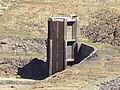 Upper intake tower exposed.
 Power station, wall and spillway.
 First sight of the reservoir.
 The shore opposite entrance point.

References
- "Nomination of Dartmouth Dam as a National Engineering Landmark" (PDF). Engineering Heritage Australia (Victoria). 1 June 2004. p. 6. Retrieved 3 January 2019.
- "Register of Large Dams in Australia" (Excel (requires download)). Dams information. The Australian National Committee on Large Dams Incorporated. 2010. Retrieved 4 March 2014.
- "Dartmouth Dam". Murray–Darling Basin Authority. Archived from the original on 12 February 2014. Retrieved 10 February 2014.
- "Dartmouth Dam". Murray Darling Basin Commission. Archived from the original on 8 September 2006. Retrieved 5 November 2006.
- "Backgrounder 4: Lake Dartmouth – Overview of Operation". Murray Darling Basin Commission. Archived from the original on 11 September 2006. Retrieved 5 November 2006.
- "Dartmouth Power Station". AGL Hydro. Archived from the original on 18 September 2006. Retrieved 13 October 2006.
- SECV, "Report of Investigation into the cause of damage of Dartmouth Power Station on 2 May 1990", State Electricity Commission of Victoria, Power Grid and Distribution Department Publications, June 1990
- "Newsletter of Engineering Heritage" (PDF). The Institution of Engineers, Australia. November 2005. Archived from the original (PDF) on 3 March 2014. Retrieved 8 February 2012.
- NSW Cold Water Pollution Interagency Group (2012) Cold Water Pollution Strategy in NSW – report on the implementation of stage one, NSW Department of Primary Industries, a division of NSW Department of Trade and Investment, Regional Infrastructure and Services, Sydney, New South Wales, ISBN 9781742563107
External links
- Current water storage levels
- Lake Dartmouth Fishing Information + Lake Maps. Sweetwater Fishing Australia
Lakes and other waterbodies of Victoria, Australia | |||||||||||||||||
|---|---|---|---|---|---|---|---|---|---|---|---|---|---|---|---|---|---|
| |||||||||||||||||
| |||||||||||||||||
| |||||||||||||||||
На других языках
[de] Dartmouth-Talsperre
Die Dartmouth-Talsperre ist eine große Talsperre am Mitta Mitta River im nordöstlichen Teil des australischen Bundesstaats Victoria. Sie liegt 24 km von dem Ort Mitta Mitta entfernt. Die Sperre schafft den künstlichen See Lake Dartmouth, der Wasser aus dem "High Country" in Victoria speichert, um es im Sommer in den Mitta Mitta (und den weiter unterhalb gelegenen Lake Hume) abzulassen, von wo aus es in den größeren Murray River fließt und dort für die Bewässerung genutzt wird. Der Hauptzweck der Dartmouth-Sperre ist es, den Wasserstand im Lake Hume konstant zu halten. Von hier wird Wasser bis nach New South Wales und South Australia geliefert.- [en] Dartmouth Dam
Другой контент может иметь иную лицензию. Перед использованием материалов сайта WikiSort.org внимательно изучите правила лицензирования конкретных элементов наполнения сайта.
WikiSort.org - проект по пересортировке и дополнению контента Википедии